
Urban Planning Digital Sand Table Modelling: Digitalizing City Blueprints
Urban Planning Digital Sand Table Modelling: Digitalizing City Blueprints
As urbanization accelerates with digital technology, the digital sandbar model for urban planning becomes a central visualization tool for municipal planning, urban construction, and commercial promotion, with a combination of digital, panoramic and interactive advantages that accurately capture the city's overall layout, functional zoning and development, as opposed to traditional planning sandpas. Blueprint。As specialized producers in the area of customizing deep-farming models, we have been able to observe the needs of the municipal planning industry with precision, focusing on the production of digital disk models for urban planning, based on an in-depth analysis of urban planning logic, digital technology and spatial layout, the in-depth integration of core elements such as urban road networks, municipal facilities, industrial parks, ecological landscapes and digital technology, the accurate reversion of urban planning in its entirety, the construction of a digital sand table model for urban planning that is both professional, digital and practical, the adaptation of the multi-area needs of the municipal planning sector, property developers, urban construction units, exhibitions, etc., to serve as a central vehicle for enabling urban planning and the transmission of urban development concepts.。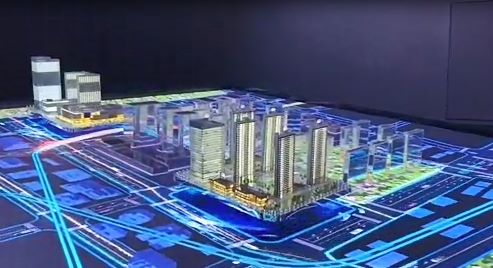
In the production process, we have always focused on “digital empowerment, precision recapture” with a pre-dependency interface with the client, specifying model uses, scope of planning, functional requirements and presentation priorities. Through field surveys, mapping of planning drawings, collection of urban basic data, construction of digital models, etc., we have been able to capture every detail of the city network, municipal facilities, ecological landscapes, architectural layouts, etc., with a strict margin of error of 0.1 per cent and a flexible adjustment of the conventional ratio to 1:200, 1:500, 1:1000。High-quality materials such as eco-durable resins, Alexis, metals, etc., are selected on the material, balancing the sense of quality and durability;Technical integration of multiple techniques, such as digital carving, fine-colouring, digital integration, dynamic simulation, and precision restoration of the urban landscape, while embedding smart digital control systems, enabling dynamic functions such as demonstration of urban zoning, road network development, ecological simulation, data queries, visualization of the scientific and forward looking nature of urban planning and matching of practical planning and presentation needs。
Question one: The breadth and complexity of urban planning, which covers a variety of core blocks such as road networks, municipalities, ecology and buildings, the different regional planning priorities and the ability of models to accurately reverse the urban planning landscape and detail while ensuring that digital functions flow smoothly?Are there any layout problems, digital failures, which do not meet the planning needs for workshops and reporting??Answer: That's our central focus. There's no such thing as this.。We have a professional technical team with senior advisers in urban planning and digital technology to conduct a thorough process of decomposition of urban planning logic and the principles of digital systems, strictly following municipal planning industry standards, restoring the specifics of planning and debugging the digital function on a case-by-case basis, based on high-precision processes and high-quality digital metaware.。Urban layout, network structure, municipal facilities are highly consistent with planned drawings, digital systems are functioning steadily, dynamic demonstrations, data queries are fluid, key elements such as planning parameters and functional partitions are clearly indicated, and the needs of various scenarios are well met。
Its applications are practical and cover the entire urban planning chain: municipal planning units can be used for planning workshops, project reporting, public awareness campaigns, support for planning and communication with the public; urban construction units can be used for project matching, construction promotion and visualization of construction planning; property developers can be used for the development of new cities and industrial parks to recruit vendors to demonstrate regional planning advantages; exhibitions can be used as core exhibits to create thematic urban development areas and upgrade the specialization of the fairs; scientific research institutions can be used for urban planning technology research and development, presentation of results and contribution to the transformation of research results; vocational colleges can be used as teaching aids to adapt to specialized teaching in urban and rural planning and municipal engineering.
