
The low-altitude economy sand-padging
The low-altitude economy sand-padging
I. CONCLUSION OF THE CONTACT OF CORRECTIVE PLAYING OF THE CORRECTIVE ECONOMY
The low-altitude economy sandpad model was developed by model producers for a variety of low-altitude economic applications such as urban low-altitude routes, vertical landings, low-altitude logistics hubs, emergency rescue low-altitude scenes, low-altitude areas of the Weng Brigade, based on regional planning drawings, low-altitude airway specifications, technical parameters of equipment and client custom requests, centred on “situation panoramic rectification, process precision reduction, functional dynamical adaptation”, and developed through mapping, three-dimensional modelling, subregional scenario construction, modular assembly, simulation, system adaptation, etc.。Its core value lies in the transformation of the low-altitude economy from a complex ecological chain of aircraft movement, route planning, landing and operation to the ancillary service, into a visual, demonstrationable and extrapolative sand table model, with “low-altitude landscape imaging, business process standardization, planning layout visualization”。
From the point of view of the target audience, the core elements of the low-altitude economy and scene carriers are covered, including low-altitude aircraft (unmanned aircraft, electric vertical lift and landing vehicle eVTOL, helicopter), landing and landing facilities (vertical landing and landing grounds, aprons, charging depots), operational control systems (routing marking, air-pipe terminals, surveillance equipment), ancillary services (low-altitude logistics sorting centres, troupe sites, emergency protection points) and floors (urban buildings, traffic networks, topography, watery vegetation);In terms of the core dimensions of the production, three main elements need to be balanced: first, proportionality adaptation (1:100 to 1:500 tailored to demonstration needs, balancing vehicle details with the regional planning global view), second, process recoupment (flying logic, flight movement rules, matching service-related workflows with actual operating specifications), and third, functional adaptation (specific functions such as cycling dynamic demonstrations, routing lights, voice movement, visualization of data, simulation of low-altitude economic performance);At the same time, different standards, such as adaptation planning, general awareness, project reporting, operational training, etc., will be used to meet the needs of a variety of scenarios in such areas as low-altitude economic parks, emergency management, civil service enterprises, research institutes, air management units, etc.。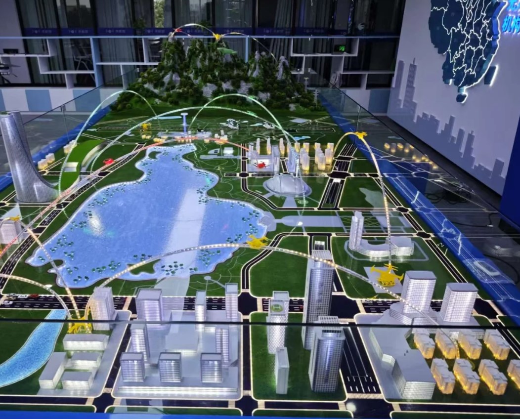
Common Questions and Answers on the Modeling of Sand Tables in Low-Air Economy
Question one: The low-altitude economic landscape involves multi-element synergetic and route control, and can the model accurately reduce the logic of the vehicle movement, taking into account the practicality of the planning exercise?
Answer: As a professional model maker, we can achieve the double standards of low-altitude operation logic replicating and planning value, perfect for low-altitude economic scenarios。In the pre-production period, the technical team will combine low-altitude economic operators and air traffic management professionals to access the regional low-altitude planning programme, flight control rules and equipment parameters and, if required to restore the actual area scene, provide on-site surveys, scene scanning services, collect sophisticated data on the height of urban buildings, terrain fluctuations, current landing points, etc., through 3-D laser scans, and ensure that the full-process logic of the operation simulation software to re-load aircraft takes off and off, move routes and resupply links is consistent with actual operating norms。In detail, the size ratio of the vehicle, the landing range marking, the route light layout, and even the exact details of the recharge station interface, the air terminal interface, and the logistics sorting centre operating line;In planning fit-out, users are supported in adjusting the position of the landing site, optimizing the layout of the flight and testing the traffic match, taking into account operational rigour and planning practicality, through mobile vehicle modules, editable flight light systems (different colours marked logistics, emergency, routing).。
Question two: How can models for different uses (planning exercises, science campaigns, project reporting) be differentiated in material processes to suit demand?
Answer: We will customize the differentiated materials process based on the core needs of the scene and the economic characteristics of the low-altitude economy, balancing durability, demonstration and adaptation of the scene。Planning scenarios (camps, air traffic management units): focus on millability and planning flexibility, main use of high-intensity engineering plastics with metal fittings, reorganisation of core modules such as urban buildings, landing grounds, repositioning of aircraft models, surfaces for smoothing, shock-resistant treatment, pre-positioning of flight link interfaces and data entry ports, and support for rapid iterative planning programmes;Science-based awareness-raising scenes (exhaustures, campuses): focus on visual impact and interaction, with the main object using light quantification of ABS engineering plastics with transparent Aclik (showing the internal structure of the vehicle, a landing range control system), through CNC processing to ensure the accuracy of the scene, with static drives, seven colour LED light systems and tactile interactive modules, to simulate the dynamic effects of the automatic lift-off, route switching, recharging, etc. of the aircraft, with voice-based presentations to spread knowledge of low-alt economy, appropriate high-frequency tours and interactions;Project reporting scenarios: focus on accuracy and quality, use of flame retardant resins, metal materials to build core elements, restoration of scene layouts and equipment points strictly according to planned drawings, size error control within > 0.1 mm, synchronized with high-resolution display screens to display core data such as shipping power, operational efficiency, appropriate for formal reporting scenarios。
Core benefits of sand table modelling in low-altitude economies
For low-altitude economic parks, emergency management authorities, civil service enterprises, scientific institutions, customizing low-altitude economic sand table models is of significant practical value and is at the heart of our focus:
1. Assisted planning for downside efficiency: Low-altitude economic planning involves complex issues such as route conflicts, landing field layouts, matching of capacity, and traditional drawings are difficult to visualize. The model allows for a “low-cost, iterative” planning exercise that helps planning teams to quickly detect route conflicts, optimize site selection, validate transport suitability, pre-empt construction risks, shorten planning landing cycles and enhance the scientific and operational viability of planning programmes.
2. Enabling low-altitude economy: the concept of low-altitude economy is relatively new, and public awareness of its applications and operating models is limited. Through dynamic demonstrations, interactive experiences, and landscape restoration, models transform abstract low-altitude business logic, application values, into visual scenes, both to spread knowledge of low-altitude economies and to demonstrate their application prospects in areas such as logistics, emergency response, and civil service, and to raise public awareness and acceptance.
3. Supplementary project reporting and operational training: In the low-altitude economic project declaration, negotiation and operational training landscape, the model visualizes the project planning layout, business model, core strengths and economic benefits, helps decision-making levels to quickly assess project value and optimize the operational programme, while providing a standardized training vehicle to the operating team to enhance personnel control over low-altitude operating processes and emergency disposal.
IV. CUSTOMS LEAST ECONOMIC CORPORATION CORPORATION MOUNTAINS AND RESULTS
Case one: A low-altitude economic park is planned for a sand table. Production
Client needs: Customize 1 1:200 City Low-Range Economic Park Sand Table for park planning rollover and negotiation, with the requirement for the restoration of 3 vertical landing sites, 5 core routes (logistics, emergency response, communications brigade), support depots and urban building foundations, with route editing, power simulations, dynamic demonstration functions, modules for the reorganization of suitable multi-version planning programmes。Upon request, the joint low-altitude planning specialists survey the site, use high-intensity engineering plastics to build the main urban building and landing field, make models of vehicles such as eVTOL, drones, etc., using metal materials, achieve vehicle dynamic lifts through programmable control systems, flight light switching, synchronized displays of transport data, modular design to support the repositioning of landing grounds and flight layouts, and mark key locations with transport nodes and conflict warning areas。Result: Model-aided park optimizes the 2nd version of the plan, successfully averts the risk of 4 routes of conflict, aggregates more than 30 batches of investors in the negotiation process, clearly communicates the park ' s operating model and core strengths, succeeds in reaching 5 cooperative intentions, and follows up with an additional upgrade to the pallet for operational rollover。
Case two: A general exhibition in an emergency section to rescue the sand table at low altitude. Production
Client needs: Customization of an 1.50 low-altitude emergency rescue interactive sandpad for presentation at the Emergency Response Section ' s general gallery, with three types of emergency scenarios covering mountains, cities and waters, with dynamic demonstration features such as drone search and rescue, eVTOL trans-shipment, terrestrial security links, support for tasting and speech interpretation, and adaptation to public insulation experience。We're using ABS engineering plastics with transparent magma-making, CNC to process the layout of the landscape landscape and emergency security points, plus touch control modules, seven colours of LED light and voice systems, to support viewers to trigger the emergency scene manually, plan rescue routes, operate aircraft to perform rescue missions, and have silent drives inside the model of the vehicle, which can simulate lift-off, suspension, trans-shipment, etc., and make surface simulations to improve the scene. Sensor.。Result: The model became the central interactive exhibit of the gallery, with an average of over 35,000 visitors per year, an increase of 60 per cent in the audience ' s awareness of low-altitude emergency relief, a high level of appreciation by emergency management and the public, followed by two additional special pallets for the gallery (low-altitude logistics, low-altitude television brigade)。
Case III: Sand Tableing of low-altitude operation training at a vocational institution Production
Client needs: Customization of 2 1:180 low-altitude operating training pallets for low-altitude economy trainees training, requirement of low-altitude logistics hubs and urban commuter scenes, aircraft movement control, route control, emergency disposal simulations, materials for milling and repeat operations, training packages and test criteria。We use high-intensity fire-retarding engineering plastics to build the main scenes, core equipment (deposition and landing grounds, air terminal, supply stations) to reset and simulate them in physical proportion, and support participants in the development of eight common operating scenarios and four emergency profiles through the control system, skills such as flight route planning, flight control, failure disposal, key location markers, operational points and performance criteria, accompanying scoring manuals and operational guidelines to assist teachers in conducting standardized training and appraisals。Result: After the model has been introduced, participants have a 40 per cent reduction in their cycle of mastery of low-altitude business processes, a 35 per cent increase in the pass rate for real-time examinations, completion of core skills training without relying on real-life vehicles, savings on the rental of equipment and the cost of space transportation of nearly $120,000 per year for institutions, and acceptance by the teaching team and the education sector as a complementary model for regional training in low-altitude economics。
